
SymbianApps: Nokia Public Transport updated to v2.1
Advertisements

Nokia Public Transport for Symbian (S^3 AND S^1) – the app for getting around via the use of public transportation vehicles is updated to v2.1 on Nokia Beta Labs. This version is also available on Nokia Store  (which they call Ovi Store :/)
Nokia Public Transport helps you navigate cities by public transportation.
http://betalabs.nokia.com/node/52351
This version is also available in Ovi Store. Please leave feedback here.  It’s the best way to get in touch with us!
- Search for public transport stations/stops, addresses and POIs.
- Choose from multiple routes and follow the list of directions for buses, trams, underground or trains.
- Have your favourite routes from your current position in the app main screen.
- See on the map how to walk to/from your station.
- Find nearby stations, departure times and even types of transit lines available around your location.
- View detailed line stops and times before you get off.
 What’s new in 2.1?
- All the platforms (S^1 and S^3-all firmwares) have now the same feature set – only difference is Transport Nearby on the map (which is only supported on Belle and newer firmwares).
- Transport Nearby in estimated routing areas.
- Improvements: battery live, start-up time, UI for Transport Nearby page, etc.
- Bug fixing.
What else is new in 2.1 for S^3 preAnna and Anna firmwares?
- Simple routing: Simple routing uses the map data to calculate a heuristic route, based on the likely frequency of lines.
- Improved experience in the available cities and increase to more cities; especially in China.
- Much more coverage: many more timetable cities + simple routing (before only Germany, UK, USA, Canada, Finland, Belgium Denmark and New Zealand)
What else is new in 2.1 new for S^1?
- Much more coverage: many more timetable cities + simple routing (before only Berlin/Brandenburg).
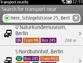
- Transport Nearby: search for a station around a certain spot and get all the departures from that station.
- Line information:Â the stops along a line and its frequency.
- Integration of Nokia Maps: walk to or show your destination on the map using Nokia Maps.
- Coverage check: at the first time usage, a coverage check will show information about the supported coverage in the user‘s city. Besides, some legal information will also presented to the user.
- Localization: now supports all languages that are available on Symbian (before only English and German)
- Lots of visual improvements.

Cheers DeathMerchant for the tip!
Advertisements
Category: Applications, Nokia, Symbian, Symbian Apps
About the Author (Author Profile)
Hey, thanks for reading my post. My name is Jay and I'm a medical student at the University of Manchester. When I can, I blog here at mynokiablog.com and tweet now and again @jaymontano. We also have a twitter and facebook accounts @mynokiablog and  Facebook.com/mynokiablog. Check out the tips, guides and rules for commenting >>click<< Contact us at tips(@)mynokiablog.com or email me directly on jay[at]mynokiablog.comSubscribe
If you enjoyed this article, subscribe to receive more just like it.


Connect
Connect with us on the following social media platforms.